From Brooklyneagle.com
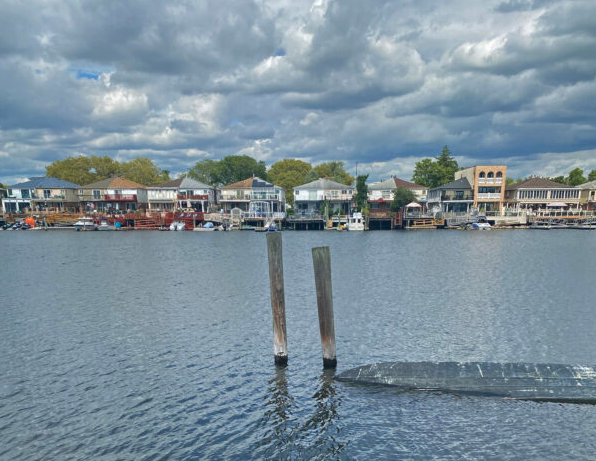
With waterfront homes equipped with boat docks, numerous boat clubs and huge swaths of parkland, the shore- line of Brooklyn’s Community Board 18 could well be the most diverse not just in the borough, but in the entire city.
CB 18’s 8.4 square miles of area encompass the communities of Mill Basin, Canarsie, Mill Island, Marine Park, Bergen Beach and Flatlands, and all of them, except Flatlands, have direct access to bodies of water as varied as the communities they embrace, including Jamaica Bay, Mill Basin, Fresh Creek, Paerdegat Basin and the waters of Marine Park’s Salt Marsh Nature Preserve.
Some of it — including the homes and boat clubs — is private property. “Mill Island is the only place in the borough of Brooklyn where you can actually have a boat in your back- yard, with the exception of a few spots in Gerritsen Beach,” noted Frank Seddio, a former assemblymember who is also the former chair and former district manager of CB 18.
“We have the most boat clubs and private marinas,” he added. Seddio pointed out, “There are six boat clubs along Paerdegat Basin.” These are the Diamond Point Yacht Club, the Hudson River Yacht Club, the Midget Squadron Yacht Club, the Paerdegat Yacht Club, Row New York Brooklyn and the Sebago Canoe Club. Also within the boundaries of CB 18 are the Boathouse Boat Club, DiMeglio Marina, Kings Plaza Ma- rina, Moonbeam Gateway Marina and Sea Travelers Marina.
CB 18’s waterfront also has a storied history, Seddio said. Canarsie, in its earlier days, was a “seafaring community,” Seddio said, noting that “a lot of the streets were paved [at one time] with oyster shells.” It, as well as nearby Bergen Beach, also had a lot of summer homes, Seddio said, for people who wanted to spend the warmer months in proximity to the water.
To accommodate summer visitors to Canarsie, beer halls and other entertainment venues sprang up, Seddio explained. There also was an amusement park at one time — Golden City — in the general vicinity of Canarsie Pier today, though it was razed in the 1930s in the name of progress, to be replaced by the Belt Parkway.
Much of the CB 18 area is parkland. Some of it is overseenby the city of New York, such as the Salt Marsh Nature Preserve in Marine Park and Fresh Creek Nature Preserve in Canarsie. The rest is under the aegis of the federal government, which controls the properties included in Gateway National Recreation Area such as Dead Horse Bay, Canarsie Pier and Floyd Bennett Field.
The latter, which hosts special events throughout the year, as well as being the home of the Aviator sporting complex, was not only the city’s first airport but also served as a naval base during World War II and afterward. “Destroyers used to dock there,” remarked Seddio, who pointed out that the Gil Hodges Marine Parkway Bridge was built to accommodate the height of large ships that needed to pass under it to dock at Floyd Bennett.
“It rivaled the Brooklyn Navy Yard,” said Seddio.
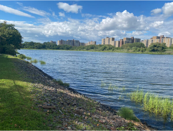
The Salt Marsh Nature Trail in Marine Park offers a very different experience. Accessed from Avenue U at East 33rd Street, across the street from the park proper, the approximately one-mile-long nature trail wends its way along the verge of the salt marsh, through a landscape defined by native plants that welcomes an array of wildlife, from turtles to swans to ospreys and pheasants, with the roster of birds varying with the season. Open since 2000, the expanse of wetlands, 530 acres in total, has been designated a Forever Wild preserve to protect it.

Marshland is the area adjacent to Fresh Creek — which is bounded by East 108th Street, Flatlands Avenue and Louisiana Avenue. The Canarsie side is only open on special occasions, because of the challenges presented by ongoing maintenance, which currently is undertaken by local volunteers, said Maria Garrett, second vice chair of CB 18 and president of the Fresh Creek Civic Association, who has spearheaded the effort to maintain the area adjacent to the creek.
“It’s at our back door,” Garrett stressed. “We want to keep it clean and tidy.” But, they also want people to learn about the preserve, she said, so on days such as the recent City of Water Day, this past July 15, the gates were open to the public so the preserve’s caretakers could share this community treasure more broadly, while teaching visitors about its importance in the local ecosystem. People wishing to explore the banks of Fresh Creek are able to do so on the Louisiana Avenue side, which is open regularly to the public, Garrett said.
In all, according to city data, 18.69% of the total area of CB 18 is zoned for parkland, more than any other community board in the borough.
It’s no surprise, therefore, abound in the CB 18 area. Those offered on the area’s water- front range from fishing at Canarsie Pier to a host of boating options, from canoes to motorboats.
Clubs such as the Sebago Canoe Club on Paerdegat Basin offer canoeing lessons, noted Garrett.
People also jet-ski “up and down Paerdegat Creek and Mill Basin Creek,” Seddio said.
In addition, urban park rangers occasionally lead boating trips into Fresh Creek from the dock at Seaview Avenue and East 108th Street or into the Salt Marsh, leaving from the nature center at Avenue U and East 33rd Street. Such events are posted on the New York City Parks Department’s website.

The National Park Service also offers waterborne programming, via kayak, leaving from Floyd Bennett Field and other sites within Gateway. For details, go to the calendar on NPS’s website.
But, it’s not just recreation. As the city looks toward its waterways to provide additional transportation options for the people who live, work and play here, CB 18’s waterfront potentially has something to offer in that respect as well.
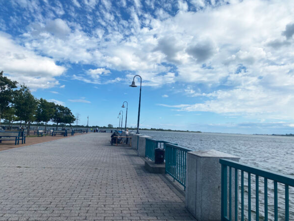
Residents of Canarsie — whose transportation consists of several bus lines and one subway line, the L, which ends at Rockaway Parkway, leaving much of the neighborhood with limited transit options — have been pushing for years to get ferry service. Former Mayor Bill de Blasio actually promised to bring the service to the neighborhood; that promise, however, is so far unfulfilled, and area residents are mobilizing to try to jumpstart the process.
Jibreel Jalloh, the founder of the Flossy Organization and a member of CB 18, has been leading the charge, spearheading a rally at Canarsie Pier on July 30 to try to bring attention to the issue.
“For too long, our community has suffered from limited transportation options, resulting in congestion, longer commutes and missed opportunities,” Jalloh contends. “We must bridge this gap and demand the connectivity we deserve. A ferry service will open doors to new possibilities, fuel economic growth and enhance our quality of life.”
Jalloh stressed that the neighborhood “is in dire need of another option to get around. Buses are super-packed during commutes, and we have congestion pricing coming,” which, he added, has the potential to impact Canarsie residents in particular, because “Canarsie is a car-heavy community.”
Among those who would benefit from a ferry are the nearly 3,600 people who live in Bay View Houses, a NYCHA development just steps from Canarsie Pier. In general, “Having a ferry here,” Jalloh contended, “is the first step in revitalizing the waterfront community.”
And, he added, ferry service from Canarsie Pier need not be limited to boats going to and from Manhattan; instead, Jalloh suggested, ferries from the pier could go to Kings Plaza, Coney Island and even Kennedy Airport.
The benefits of CB 18’s varied waterfront are clearly nu- merous. But the proximity to the water also brings challenges. Flooding issues became significant in the wake of Superstorm Sandy in 2012, particularly in Canarsie, which was the hardest hit of the board’s neighborhoods; the threat is exacerbated be- cause much of the area was built up on marshland.
Former CB 18 Chair Gardy Brazela noted that the Canarsie civic organization he founded, the Friends United Block Association, got its start because basement flooding was such a problem in the area.
“Canarsie was built on a swamp,” he explained, stressing that the sewer system, which – like that in much of New York City — is old, couldn’t handle the added demand, thus the drenched basements. While city agencies, he said, had “alleviated” the problem, “They didn’t solve it.”
Garrett said that Sandy caused flooding from Fresh Creek as well as from overflowing sewers. “All hell broke loose,” she recalled. “I had about three and a half feet of water in my basement.
“Canarsie always had sewer problems,” she added. “All the catchbasins used to flood [after heavy rains] so you couldn’t even walk there.”
Efforts to resolve the issue after Sandy finally bore fruit in 2019 with a coastal protection project that involved installing tide chambers between Avenue K and Seaview Avenue, said Garrett; the chambers work by preventing an overage of water from flow- ing into the sewer system when tides get too high, Garrett ex- plained. That project was finished in 2022, and this past April, new trees and bushes were planted in the nature preserve.
Mill Island — whose suburbs-in-the-city vibe attracts residents such as Sol Needle, president of the Mill Island Civic Association — also experienced flooding. After Sandy, some people, Needle said, “had over 4-1/2 feet of water in their basements.” The next challenge came, he recalled, in trying to get help for homeowners, because residents either didn’t have flood insurance or payouts were limited.
“Eventually,” Needle said, “the federal government stepped up. Otherwise, everyone would have been up the creek.”
Given the board area’s geography, it isn’t surprising there- fore that when CB 18 issued its Fiscal Year 2024 statement of needs — a document prepared by each of the city’s community boards each year — two of the three top priorities articulated relate to parkland and infrastructure resiliency.
“The dream of a restored Floyd Bennett Field for recreational use with water access must not be forgotten,” the board contended. “The restoration of the boat docks at Floyd Bennett Field and at Canarsie Pier would allow for the on-again, off-again use of water ferries at peak times to facilitate the movement of participants of large outdoor events as well as visitors to the Park, the islands off the coast of Canarsie, the sports entertainment complex at Floyd Bennett Field, and it would enable commuter connection with other parts of the borough and city.”
In addition, the board chastised the city for dragging its heels in terms of shoring up the ability of the communities near the water’s edge to withstand a future Sandy-like storm.
Over a decade after Sandy, “We remain appalled by the lack of speed and clarity in not developing a strengthened coastal defense resiliency plan for our shoreline as the first line of defense against flooding and sea level rise,” the FY 2024 statement of needs reads. “The hopes that all the shore communities shared after Oct. 29, 2012, have never been realized and have been ‘washed away’ in a sea of bureaucracy, indifference and red tape. Long-range storm protection remains one of our top priorities. We must continue to partner with all levels of Government to make this battle to protect our shoreline communities a reality rather than another report lying in a pile of reports in some agency.”
Among the measures the board is calling for are seawalls and gates “around the waterfront that could open or close in a storm threat to divert or redirect the surge.”
CB 18 Chairperson Michael Ien recalls the devastation vividly.
“After Sandy, portions of the area looked like a third- world country,” he said. “I hope it doesn’t happen again, but, in the event it does, we need resiliency measures. Sandy was 11 years ago. Not enough has been done, and it’s taking too long.”
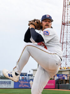 Cyclones flirt with a second no-hitter
  Another iconic mural painted on Fifth Avenue